
Krieshen Ramkhelawan
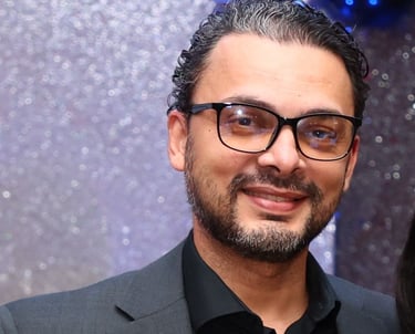
I'm an information scientist and technology entrepreneur based in Paramaribo, Suriname, working where geospatial intelligence meets digital government and organisational change. I lead GISsat N.V., the authorised Esri distributor for Suriname since 1999, and co-own Lybra Training, Coaching & Consulting, where I direct innovation and research. My work is about helping institutions turn spatial data into decisions — and making sure the systems they build are actually adopted.

Who I am


Most people meet me through Geographic Information Systems (GIS), but my foundation is information systems, not cartography. I trained as an information scientist, spent my early career in process and change management, and came to geospatial technology as a means to a larger end: institutions that manage land, infrastructure and public services on the basis of reliable, shared information. Fifteen years in land administration and geospatial systems have taught me that the technology is usually the easy part. Getting it into daily institutional practice is the work.
From information systems to geospatial transformation
I hold a Master of Science (MSc) in Information Sciences from Vrije Universiteit Amsterdam. My early career was in process and change management — at ING in Belgium and Amsterdam and at the Ministerie van Financiën — alongside lecturing at the FHR School of Business. In 2011 I joined MI-GLIS, Suriname's land-registration and land-information institute, as Information & Change Manager, leading information systems and change management until 2015 during the modernisation of the public-domain cadastre; I later advised its board. That experience — seeing what it takes for a technically sound system to become an institution's routine — has shaped everything since.
Building Suriname's geospatial ecosystem
I have led GISsat N.V. as Director since 2022. GISsat has been Esri's sole authorised distributor for Suriname since 1999 and a Trimble partner since 2003, with further technology partnerships including Merkator and Codex Brazil. Our team delivers enterprise GIS platforms and geospatial consulting to government ministries and to organisations across energy, telecommunications, utilities, forestry, mining, insurance and national statistics. Beyond client work, I have tried to build the community itself: I organised SuriGIS in 2018, Suriname's first national spatial data infrastructure (SDI) event; founded the Suriname GIS User Conference in 2022, now in its fifth edition; and in 2026 launched GeoGov Suriname, a programme to institutionalise geospatial intelligence across government.
From GIS projects to digital government
The projects I value most are the ones that changed how an institution works, not just what it could map: the parcel administration platform at MI-GLIS, geospatial work for the Algemeen Bureau voor de Statistiek (ABS) on Suriname's ninth national census, and the Inter-American Development Bank (IDB) Geospatial Intelligence Hub, delivered in 2024 with the Ministry of Spatial Planning and Environment (MinROM) and Codex Brazil.
Through Lybra I complement the technology with the human side of transformation — leadership development, coaching, certification training, ArcGIS training and drone mapping — because the last mile of any GIS is people and process, not software.
The same question now extends to artificial intelligence (AI). I have written GISsat's AI usage policy, trained our team, and work on where AI and automation fit into geospatial workflows. My thinking is framed by the United Nations Integrated Geospatial Information Framework (UN-IGIF) and by a question I keep returning to: what does whole-of-government geospatial transformation look like in a small developing economy?
Research, speaking and media
I write as a practitioner. In 2026 I published two preprints on ResearchGate: a practitioner assessment of Suriname's whole-of-government geospatial transformation through the UN-IGIF lens, and Bridging the Last Mile of GIS, which sets out the 6Ps Framework for moving from technology to institutional adoption. In 2020, GIM International published my article on the modernisation of Suriname's public-domain cadastre. I speak regularly at the Esri User Conference in San Diego, at the Suriname GIS User Conference and at GIS Day events in Suriname, and my work has been covered by de Ware Tijd and GIM International. Full references are listed below.
Beyond technology
Outside my professional work I compose meditative and frequency-based music — a creative practice that runs alongside the technical one. You can listen on the Music page.


Publications
1. Ramkhelawan, K. (2026). From Land Registry to Digital Government: A Practitioner Assessment of Suriname's Whole-of-Government Geospatial Transformation Through the UN-IGIF Lens. Preprint, ResearchGate. DOI
2. Ramkhelawan, K. (2026). Bridging the Last Mile of GIS: A Change-Management Framework for Digital Transformation in Small Developing Economies. Preprint, ResearchGate. DOI
3. Ramkhelawan, K. (2020). Modernization of Suriname's Public Domain Cadastre. GIM International. Read article
Profiles: ORCID · ResearchGate
Short bio for event organisers
Krieshen Ramkhelawan, MSc, is Director of GISsat N.V., the authorised Esri distributor for Suriname since 1999. An information scientist (Vrije Universiteit Amsterdam) with fifteen years in land administration and geospatial systems, he founded the Suriname GIS User Conference and the GeoGov Suriname programme and publishes practitioner research on GIS adoption and the UN-IGIF. He speaks regularly at the Esri User Conference and at regional GIS events, and works in Dutch and English.